Several towns started near Bremen never reached a self-sustaining size. The remarkable document below tells part of the tale; it is the official postmaster record for Marshall county, and lists the towns, their postmasters, and their name changes over time. History books and newspaper accounts hold pieces of others.
Click the image to display a larger version. Depending on your display, you may need to click it again to view the full-size version.

Bremen shows up first as “Brothersville” with postmaster David Brothers in 1847, changing to “Bremen” in 1848 six months after George Pomeroy took over. Prior to the establishment of the post office, the community was referred to as “New Bremen”.
Note that Bourbon’s post office was established in 1843, but discontinued in 1845, then reestablished in 1847.
Clayton
Clayton apparently never really got off the ground. There are a couple of references to it in Marshall county history books, and it was surveyed by the Klinger brothers, who also surveyed Bremen, but there’s no indication that the “gorgeous streets and avenues” were actually cut. It was co-founded by one of the men who is central to South Bend history, Lathrop M Taylor, and likely named—as Clay township and Clay High School were—after popular politician Henry Clay.
One history tells that Josiah Geiselman came to Bremen from Clayton, where he had run a country store. In Bremen, he started a blacksmith shop where the Dietrich department store was later built, across from George Pomeroy’s general store (where the Downtown’r is today).
Clayton was the name of the first town site located in German Township. This was August 21, 1837. The proprietors were Lathrop M. Taylor and Henry Augustine, of South Bend. Mr. Taylor was at that time Clerk of St. Joseph County. The location was about three miles east of the present town of Bremen. Its form was a diagonal, cut up into gorgeous streets and avenues. But the center of gravity did not seem to be in that region, and the project of building a town there was abandoned.
Roscoe Huff, in his 1931 memoir included in Ernest O Annis’s The Family of John Phillip Huff, says:
The trading center for that neighborhood was Mishawaka, though there was a little village called Clayton which was the first town site located in German Township, to which the Huff family occasionally went for trading. This village was located about a mile east of the present town of Bremen on what is now I believe the William Fries farm [probably William H Fries (1880-1940)]. It was laid out and plotted by Lathrop M. Taylor [a fur trader who helped found South Bend (1805-1892)] and Henry Augustine [probably War of 1813 veteran Henry Augustine (1796-1865)] of South Bend, but it never grew to anything but a settlement of a few houses on a high spot pretty much surrounded by swamps and later on was completely abandoned and destroyed.
The Fries/Freese farm one mile east of Bremen is just east of Huff’s Hill. There’s no evidence of any community there in the map of 1881 or after. But three miles east would surely put Clayton in the same place as Millville.
Millville / Berlinton / Ayr
Millville grew up three miles east of Bremen near the Kosciusko county line but unlike Taylor and Augustine’s Clayton seems to be an organic gathering of shops, including a store, wagon shop, and stave (barrel) shop by 1881, and not laid out in a diagonal.
The Bremen Public Library notes “There is a handwritten note on our copy of this map pointing to Millville that states ‘Later Berlinton’.”

The east-west road is 2B. The north-south road is Beech. The area is just south of Ayr Cabinet and Burkolder Buildings & Supply, just north of Miller Stove & Fireplace.
In 1895, Berlinton’s post master was J F Mattern, probably John Mattern, who committed suicide two years later.

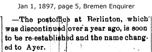
A piece in the Bremen Enquirer in 1897 notes that Berlinton has changed its name to “Ayr” after reinstating its post office.

In 1897, the post master of the newly renamed hamlet was William S Clindaniel.

Ayr was discontinued in 1903 and mail was routed to Nappanee for delivery. The community continued to be referred to by both names into the 1950s, and is the source of the name of Ayr Cabinet Company on US 6.

Linkville & Harris Station
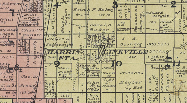
Linkville/Linksville and Harris Station were villages about a mile apart just east of Michigan Road (old US 31), with latter being a depot on the now-defunct Vandalia north-south line.

This village is situated about five miles northeast of the county seat, in the southeastern part of North township. The proprietors were Simon Stough, M. J. Link and E. J. Mosholder. It was laid out June 9, 1866, and contains twelve lots. It is a neighborhood village, conveniently situated as to the various parts of the township, and the county seat, as well as on the main road to Bremen and Lake of the Woods.
The two villages shared a post office that lasted until 1903, but both communities remained on maps until at least 1908. Today, both are residential property, with Harris Station at the kink in 4A Rd on the east side of Tri-Way Golf Course.
East La Paz
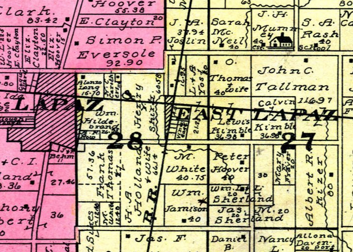
Lapaz was originally called “Walnut Hill” and then “La Paz”. East La Paz was a separate community between Lapaz and Bremen but probably never much more than an extension of the town out to the railroad line
East La Paz is about three-fourths of a mile east of the original La Paz at the junction of the Baltimore & Ohio railroad and the Logansport & Terre Haute railroad, and is described as follows by Walter Kimble, the proprietor, his plat being filed for record February 14, 1855: “East La Paz is situated in southeast quarter of northeast quarter of section twenty-eight (28), township thirty-five (35) north, range two (2) east, at the crossing of the Baltimore & Ohio & Vandalia railroad, is bounded on the east by Vandalia railroad, on the south, west and north by the boundary line of said southeast quarter of the northeast quarter.”
By 1881, there was nothing of note in the area. But even in 1908, after the short-lived Vandalia (Logansport & Terre Haute) Railroad went through, there was enough that the map-makers fully labeled it.

Other communities
The Bremen Enquirer sometimes mentioned German township residents by the rural school district they lived in. A dozen tiny schools were scattered around the township, and this was a handy way of referring to the farm families around them. Morningstar school, which was district 11, was located in the southeast corner of the township.


06/13/2024 at 1:37 pm
UGH Walnut Hill IS la Paz?! thank u
LikeLike